
Thank you for supporting this site ❤️
Make a donation
Make a donation
Gear up for your next adventure:
As an Amazon Associate, this site earns from qualifying purchases at no extra cost to you.
Pedregosa topographic map
Click on the map to display elevation.
Thank you for supporting this site ❤️
Make a donation
Make a donation
Gear up for your next adventure:
As an Amazon Associate, this site earns from qualifying purchases at no extra cost to you.
About this map
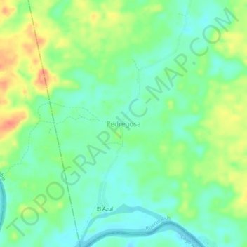
Name: Pedregosa topographic map, elevation, terrain.
Location: Pedregosa, Puerto Asís, Putumayo, RAP Amazonía, Colombia (0.25836 -76.65423 0.29836 -76.61423)
Average elevation: 866 ft
Minimum elevation: 801 ft
Maximum elevation: 981 ft
Thank you for supporting this site ❤️
Make a donation
Make a donation
Gear up for your next adventure:
As an Amazon Associate, this site earns from qualifying purchases at no extra cost to you.