
Make a donation
Gear up for your next adventure:
As an Amazon Associate, this site earns from qualifying purchases at no extra cost to you.
Alastaro topographic map
Click on the map to display elevation.
Make a donation
Gear up for your next adventure:
As an Amazon Associate, this site earns from qualifying purchases at no extra cost to you.
About this map
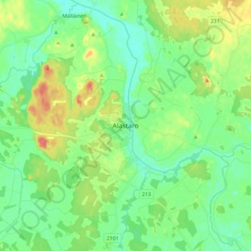
Name: Alastaro topographic map, elevation, terrain.
Average elevation: 262 ft
Minimum elevation: 203 ft
Maximum elevation: 387 ft
Make a donation
Gear up for your next adventure:
As an Amazon Associate, this site earns from qualifying purchases at no extra cost to you.
Other topographic maps
Click on a map to view its topography, its elevation and its terrain.
Turku
Operational since 1955, the city's weather station is located at an altitude of 47 metres (154 feet) at Turku Airport. The weather in the city itself is affected by the proximity of the sea, so the wintertime temperatures are often milder than those measured at the airport. The moderating impact of the sea…
Average elevation: 105 ft
Make a donation
Gear up for your next adventure:
As an Amazon Associate, this site earns from qualifying purchases at no extra cost to you.
Make a donation
Gear up for your next adventure:
As an Amazon Associate, this site earns from qualifying purchases at no extra cost to you.
Make a donation
Gear up for your next adventure:
As an Amazon Associate, this site earns from qualifying purchases at no extra cost to you.
Make a donation
Gear up for your next adventure:
As an Amazon Associate, this site earns from qualifying purchases at no extra cost to you.
Turku
Operational since 1955, the city's weather station is located at an altitude of 47 metres (154 feet) at Turku Airport. The weather in the city itself is affected by the proximity of the sea, so the wintertime temperatures are often milder than those measured at the airport. The moderating impact of the sea…
Average elevation: 105 ft
Make a donation
Gear up for your next adventure:
As an Amazon Associate, this site earns from qualifying purchases at no extra cost to you.
Turku
Operational since 1955, the city's weather station is located at an altitude of 47 metres (154 feet) at Turku Airport. The weather in the city itself is affected by the proximity of the sea, so the wintertime temperatures are often milder than those measured at the airport. The moderating impact of the sea…
Average elevation: 105 ft
Make a donation
Gear up for your next adventure:
As an Amazon Associate, this site earns from qualifying purchases at no extra cost to you.
Make a donation
Gear up for your next adventure:
As an Amazon Associate, this site earns from qualifying purchases at no extra cost to you.