
Red Wing topographic map
Click on the map to display elevation.
Red Wing
According to the United States Census Bureau, the city has an area of 41.19 square miles (106.68 km2), of which 34.60 square miles (89.61 km2) is land and 6.59 square miles (17.07 km2) is water. The city is at the northern edge of the Driftless Area of karst topography.
About this map
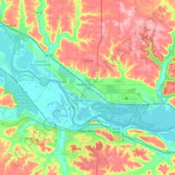
Name: Red Wing topographic map, elevation, terrain.
Location: Red Wing, Goodhue County, Minnesota, 55066, United States (44.52796 -92.67277 44.66966 -92.46723)
Average elevation: 863 ft
Minimum elevation: 653 ft
Maximum elevation: 1,158 ft
Goodhue County trails, hiking, mountain biking, running and outdoor activities
Other topographic maps
Click on a map to view its topography, its elevation and its terrain.
Grand View Mobile Park
United States > Minnesota > Goodhue County > Red Wing
Average elevation: 817 ft
Cannon Falls
United States > Minnesota > Goodhue County > Cannon Falls > Cannon Falls
Average elevation: 879 ft