Geolocate

Castello topographic map

Click on the map to display elevation.

About this map

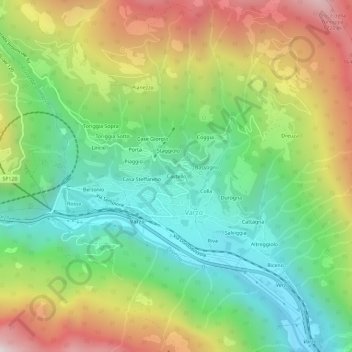
Name: Castello topographic map, elevation, terrain.

Location: Castello, Varzo, Verbano-Cusio-Ossola, Piedmont, 28868, Italy (46.19083 8.23164 46.23083 8.27164)

Average elevation: 3,209 ft

Minimum elevation: 1,440 ft

Maximum elevation: 6,001 ft

Gear up for your next adventure:

📡Handheld GPS Device - Reliable handheld GPS for outdoor navigation
🗺️NatGeo Topo Maps - High-quality waterproof printed topographic maps of US Parks
🧣Hiking Neck Gaiter - Multi‑use neck protection for outdoor weather
🔭Stargazing Telescopes - Perfect for camping in low-light pollution areas shown on maps
🧣Merino Neck Gaiters - Multi-functional headwear for wind and sun protection

As an Amazon Associate, this site earns from qualifying purchases at no extra cost to you.