
Thank you for supporting this site ❤️
Make a donation
Make a donation
Gear up for your next adventure:
As an Amazon Associate, this site earns from qualifying purchases at no extra cost to you.
Mazzarino topographic map
Click on the map to display elevation.
Thank you for supporting this site ❤️
Make a donation
Make a donation
Gear up for your next adventure:
As an Amazon Associate, this site earns from qualifying purchases at no extra cost to you.
About this map
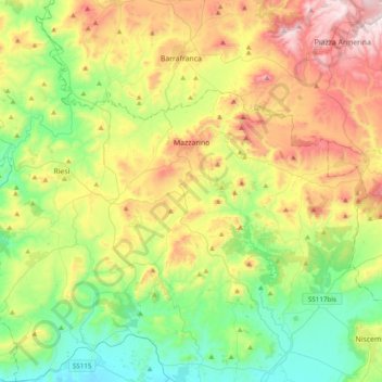
Name: Mazzarino topographic map, elevation, terrain.
Location: Mazzarino, Caltanissetta, Sicile, 93013, Italie (37.16420 14.00534 37.36709 14.39250)
Average elevation: 1,073 ft
Minimum elevation: 33 ft
Maximum elevation: 2,861 ft
Thank you for supporting this site ❤️
Make a donation
Make a donation
Gear up for your next adventure:
As an Amazon Associate, this site earns from qualifying purchases at no extra cost to you.