Geolocate

Tarout topographic map

Click on the map to display elevation.

About this map

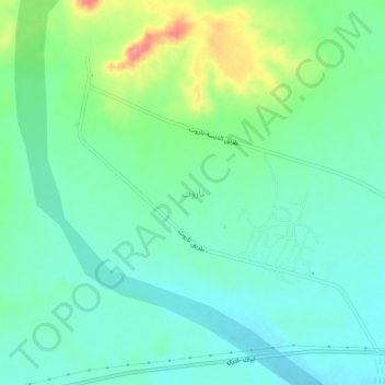
Name: Tarout topographic map, elevation, terrain.

Location: Tarout, Wadi al Shatii, Libya (27.49447 13.90521 27.53447 13.94521)

Average elevation: 1,148 ft

Minimum elevation: 1,063 ft

Maximum elevation: 1,371 ft

Other topographic maps

Click on a map to view its topography, its elevation and its terrain.

AZWAIYA

Libya > Wadi al Shatii

Average elevation: 1,240 ft

Al Mahruqah

Libya > Wadi al Shatii

Average elevation: 1,135 ft

Gear up for your next adventure:

🌐World Map Poster - Decorative world maps with topographic info
🚑Emergency Bivvies - Heat-reflective sleeping bags for survival situations
🌎3D Topographic Globes - Raised relief globes for a tactile understanding of geography
🧢Sun Protection Hats - Wide-brimmed and UPF-rated hats for high-altitude sun safety
🪄Magnetic Compass - Accurate compass for navigation

As an Amazon Associate, this site earns from qualifying purchases at no extra cost to you.