Geolocate

Zliten topographic map

Click on the map to display elevation.

About this map

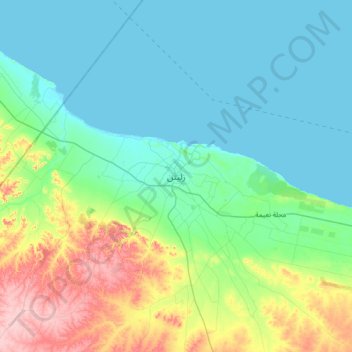
Name: Zliten topographic map, elevation, terrain.

Location: Zliten, Bani Walid, Libya (32.30756 14.40564 32.62756 14.72564)

Average elevation: 115 ft

Minimum elevation: 0 ft

Maximum elevation: 472 ft

Gear up for your next adventure:

🔦Powerful Headlamps - Ultra-bright hands-free lighting for night navigation
🦺Reflective Outdoor Gear - Safety gear for low‑light conditions
🪑Portable Camp Table - Compact table for campsite meals
🛠️Outdoor Gear Repair Kit - Essential tools to fix gear on the trail
🚑Emergency Bivvies - Heat-reflective sleeping bags for survival situations

As an Amazon Associate, this site earns from qualifying purchases at no extra cost to you.