Geolocate

Isla Guafo topographic map

Click on the map to display elevation.

About this map

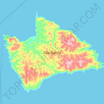
Name: Isla Guafo topographic map, elevation, terrain.

Location: Isla Guafo, Provincia de Chiloé, Los Lagos Region, Chile (-43.67818 -74.83462 -43.51754 -74.55333)

Average elevation: 171 ft

Minimum elevation: -3 ft

Maximum elevation: 1,112 ft

Other topographic maps

Click on a map to view its topography, its elevation and its terrain.

Linao

Chile > Los Lagos Region > Provincia de Chiloé > Ancud

Average elevation: 72 ft

Gear up for your next adventure:

👖Convertible Hiking Pants - Versatile zip-off pants for changing altitudes and temperatures
⛑️Personal Locator Beacon - Safety beacon for emergencies
💧Water Purification System - Clean water on the trail with reliable purifiers
🧭Map Reading Tools - Tools and kits for map navigation
🖼️Topo Map Wall Art - Decorative topographic prints of famous peaks and regions

As an Amazon Associate, this site earns from qualifying purchases at no extra cost to you.