Geolocate

Solapur topographic map

Click on the map to display elevation.

Solapur

Solapur is located at 17°41′N 75°55′E / 17.68°N 75.92°E / 17.68; 75.92. It has an average elevation of 458 metres (1502 feet). It is bordered by Ahmednagar district on the north; Osmanabad district on the north and northeast.

Wikipedia (CC-BY-SA 3.0)

About this map

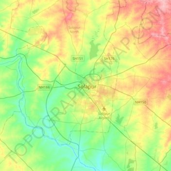
Name: Solapur topographic map, elevation, terrain.

Location: Solapur, Solapur North, Solapur District, Maharashtra, 413001, India (17.50997 75.74081 17.82997 76.06081)

Average elevation: 1,539 ft

Minimum elevation: 1,391 ft

Maximum elevation: 1,775 ft

Gear up for your next adventure:

🥾Women's Hiking Boots - Top-rated trail boots with ankle support and superior grip
🧦Hiking Socks - Comfortable socks to prevent blisters on long hikes
🎒Outdoor Daypacks - Lightweight backpacks designed for carrying maps and essential gear
🥘Titanium Cookware - Durable, featherlight pots and pans for backpacking
🥤Water Filter Bottle - All‑in‑one filter bottle for safe hydration

As an Amazon Associate, this site earns from qualifying purchases at no extra cost to you.