
Make a donation
Gear up for your next adventure:
As an Amazon Associate, this site earns from qualifying purchases at no extra cost to you.
Aspet topographic map
Click on the map to display elevation.
Make a donation
Gear up for your next adventure:
As an Amazon Associate, this site earns from qualifying purchases at no extra cost to you.
Aspet
Located in the middle of the Pyrenees mountain chain, within the ancient region of Comminges, Aspet sits 15 km south to Saint-Gaudens and at the foot of the Cagire (1,912 metres (6,273 ft) in Altitude).
Make a donation
Gear up for your next adventure:
As an Amazon Associate, this site earns from qualifying purchases at no extra cost to you.
About this map
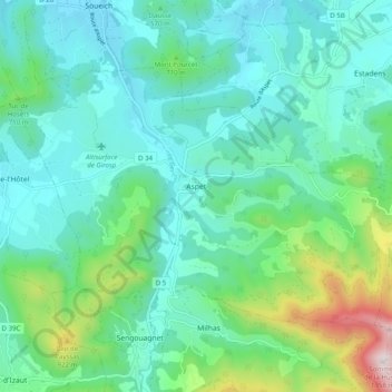
Name: Aspet topographic map, elevation, terrain.
Average elevation: 1,913 ft
Minimum elevation: 1,263 ft
Maximum elevation: 4,396 ft
Make a donation
Gear up for your next adventure:
As an Amazon Associate, this site earns from qualifying purchases at no extra cost to you.
Other topographic maps
Click on a map to view its topography, its elevation and its terrain.
Make a donation
Gear up for your next adventure:
As an Amazon Associate, this site earns from qualifying purchases at no extra cost to you.