Geolocate

Balugo topographic map

Click on the map to display elevation.

About this map

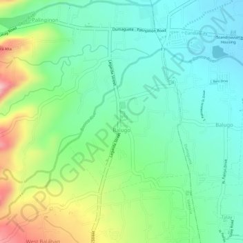
Name: Balugo topographic map, elevation, terrain.

Location: Balugo, Valencia, Negros Oriental, Negros Island Region, Philippines (9.29552 123.24479 9.31176 123.25854)

Average elevation: 390 ft

Minimum elevation: 197 ft

Maximum elevation: 758 ft

Other topographic maps

Click on a map to view its topography, its elevation and its terrain.

Valencia

Philippines > Negros Oriental > Valencia

Valencia occupies an area of 14,749 hectares (36,450 acres), 35% of which are classified as plains. The town is 65% mountainous, with elevation averaging from 200 to 500 metres (660 to 1,640 ft) above sea level, with the top of Mount Talinis at an elevation of 1,903 metres (6,243 ft) along the municipal…

Average elevation: 820 ft

PulangBato Falls

Philippines > Negros Oriental > Valencia > Malabo

Average elevation: 1,821 ft

Malabo

Philippines > Negros Oriental > Valencia

Average elevation: 1,824 ft

Pulangbato

Philippines > Negros Oriental > Valencia

Average elevation: 1,555 ft

Bangalon Fountain

Philippines > Negros Oriental > Valencia > Jawa

Average elevation: 663 ft

Bongbong

Philippines > Negros Oriental > Valencia

Average elevation: 1,119 ft

Puhagan

Philippines > Negros Oriental > Valencia

Average elevation: 2,963 ft

Sagbang

Philippines > Negros Oriental > Valencia

Average elevation: 1,148 ft

Puhagan

Philippines > Negros Oriental > Valencia

Average elevation: 2,963 ft

Gear up for your next adventure:

📦Gear Storage Bags - Organize and protect outdoor equipment
🎒Waterproof Dry Bags - Keep your electronics and maps dry inside your pack
🔦LED Headlamp - Bright and durable LED headlamp for night navigation
🌎3D Topographic Globes - Raised relief globes for a tactile understanding of geography
🔋Rechargeable Batteries - Power up your outdoor devices

As an Amazon Associate, this site earns from qualifying purchases at no extra cost to you.