
Make a donation
Gear up for your next adventure:
As an Amazon Associate, this site earns from qualifying purchases at no extra cost to you.
Mihara topographic map
Click on the map to display elevation.
Make a donation
Gear up for your next adventure:
As an Amazon Associate, this site earns from qualifying purchases at no extra cost to you.
Mihara
Mihara is located in south-central Hiroshima Prefecture. It faces the Seto Inland Sea to the south, and part of the coastline forms part of the Setonaikai National Park. The origin of the name of "Mihara" is from the alluvial fans of Yubara, Komagahara, and Konishihara Rivers. The Numata River, a second-class river that originates from the Kamo plateau of Higashihiroshima City, flows through the center of the city, and the central urban area flourishes at its mouth. Most of the current central city area is reclaimed land, and steep mountains approach the coastline, while the northern part is a highland area with an elevation of 400 meters or more at the southern tip of Kibi Plateau, and the western part is mostly hilly.
Make a donation
Gear up for your next adventure:
As an Amazon Associate, this site earns from qualifying purchases at no extra cost to you.
About this map
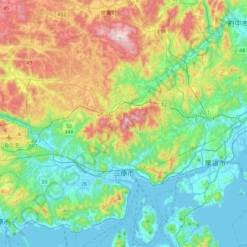
Name: Mihara topographic map, elevation, terrain.
Location: Mihara, Hiroshima Prefecture, Japan (34.30384 132.84740 34.59367 133.16249)
Average elevation: 640 ft
Minimum elevation: -10 ft
Maximum elevation: 2,238 ft
Make a donation
Gear up for your next adventure:
As an Amazon Associate, this site earns from qualifying purchases at no extra cost to you.
Other topographic maps
Click on a map to view its topography, its elevation and its terrain.
Make a donation
Gear up for your next adventure:
As an Amazon Associate, this site earns from qualifying purchases at no extra cost to you.
Make a donation
Gear up for your next adventure:
As an Amazon Associate, this site earns from qualifying purchases at no extra cost to you.
Make a donation
Gear up for your next adventure:
As an Amazon Associate, this site earns from qualifying purchases at no extra cost to you.