
Zeppenfeld topographic map
Click on the map to display elevation.
About this map
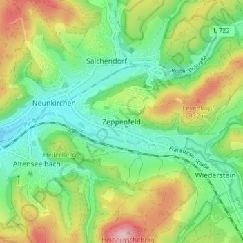
Name: Zeppenfeld topographic map, elevation, terrain.
Average elevation: 1,102 ft
Minimum elevation: 823 ft
Maximum elevation: 1,594 ft
Other topographic maps
Click on a map to view its topography, its elevation and its terrain.
Siegen
Germany > North Rhine-Westphalia > Kreis Siegen-Wittgenstein
The city's total land area is roughly 115 km2 (44 sq mi). Its greatest east-west span is about 12 km (7 mi), and its greatest north-south span is about 12 km (7 mi). City limits are 48 km (30 mi) long. Siegen lies at a median elevation of 290 m (951 ft) above sea level. The city's greatest elevation is the…
Average elevation: 1,135 ft
Bad Laasphe
Germany > North Rhine-Westphalia > Kreis Siegen-Wittgenstein
The highest elevation in the municipal area rises to 694 m. It lies southwest of the main town at the outlying centre of Heiligenborn.
Average elevation: 1,522 ft
Dahlbruch
Germany > North Rhine-Westphalia > Kreis Siegen-Wittgenstein > Hilchenbach
Average elevation: 1,204 ft
Siegen
Germany > North Rhine-Westphalia > Kreis Siegen-Wittgenstein
The city's total land area is roughly 115 km2 (44 sq mi). Its greatest east-west span is about 12 km (7 mi), and its greatest north-south span is about 12 km (7 mi). City limits are 48 km (30 mi) long. Siegen lies at a median elevation of 290 m (951 ft) above sea level. The city's greatest elevation is the…
Average elevation: 1,135 ft
NSG Erzebachtal
Germany > North Rhine-Westphalia > Kreis Siegen-Wittgenstein > Kreuztal > Fellinghausen
Average elevation: 1,079 ft