Geolocate

Pliny topographic map

Click on the map to display elevation.

👉 Easily get elevation data in JSON, GeoTIFF and KML formats using Elevation API
Thank you for supporting this site ❤️
Make a donation

About this map

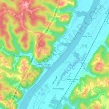
Name: Pliny topographic map, elevation, terrain.

Location: Pliny, Putnam County, West Virginia, 25033, United States (38.60036 -82.00736 38.64036 -81.96736)

Average elevation: 696 ft

Minimum elevation: 545 ft

Maximum elevation: 971 ft

Putnam County trails, hiking, mountain biking, running and outdoor activities

Other topographic maps

Click on a map to view its topography, its elevation and its terrain.

Poca

United States > West Virginia > Putnam County

Average elevation: 709 ft

Winfield

United States > West Virginia > Putnam County

Average elevation: 732 ft

Gear up for your next adventure:

🪶Compact Camp Shovel - Folding shovel for campsite tasks
🧣Hiking Neck Gaiter - Multi‑use neck protection for outdoor weather
💧Water Purification System - Clean water on the trail with reliable purifiers
🔋Solar Power Banks - Keep your GPS and phone charged in remote wilderness areas
🔦Compact Flashlight - Reliable flashlight for emergencies

As an Amazon Associate, this site earns from qualifying purchases at no extra cost to you.