Make a donation
Gear up for your next adventure:
As an Amazon Associate, this site earns from qualifying purchases at no extra cost to you.
Bario topographic map
Click on the map to display elevation.
Make a donation
Gear up for your next adventure:
As an Amazon Associate, this site earns from qualifying purchases at no extra cost to you.
Bario
Bario is a community of 13 to 16 villages located on the Kelabit Highlands in Miri Division, Sarawak, Malaysia, lying at an altitude of 1000 m (3280 ft) above sea level. It is located close to the Sarawak-Kalimantan border, 178 km to the east of Miri. It is the main settlement for the indigenous Kelabit tribe. There are regular flights between the Bario, Miri and Marudi.
Make a donation
Gear up for your next adventure:
As an Amazon Associate, this site earns from qualifying purchases at no extra cost to you.
About this map
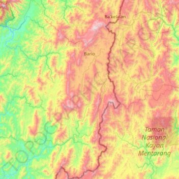
Name: Bario topographic map, elevation, terrain.
Location: Bario, Miri, Miri Division, Sarawak, Malaysia (2.97373 115.05477 4.08620 115.65222)
Average elevation: 3,068 ft
Minimum elevation: 407 ft
Maximum elevation: 7,746 ft
Make a donation
Gear up for your next adventure:
As an Amazon Associate, this site earns from qualifying purchases at no extra cost to you.
Other topographic maps
Click on a map to view its topography, its elevation and its terrain.
Make a donation
Gear up for your next adventure:
As an Amazon Associate, this site earns from qualifying purchases at no extra cost to you.
Make a donation
Gear up for your next adventure:
As an Amazon Associate, this site earns from qualifying purchases at no extra cost to you.
Make a donation
Gear up for your next adventure:
As an Amazon Associate, this site earns from qualifying purchases at no extra cost to you.
Make a donation
Gear up for your next adventure:
As an Amazon Associate, this site earns from qualifying purchases at no extra cost to you.
Make a donation
Gear up for your next adventure:
As an Amazon Associate, this site earns from qualifying purchases at no extra cost to you.
