Geolocate

Cayey topographic map

Click on the map to display elevation.

About this map
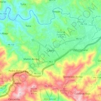
Name: Cayey topographic map, elevation, terrain.

Location: Cayey, Puerto Rico, 00737, United States (18.07275 -66.20634 18.15275 -66.12634)

Average elevation: 1,604 ft

Minimum elevation: 932 ft

Maximum elevation: 2,756 ft

Cayey trails, hiking, mountain biking, running and outdoor activities

Other topographic maps

Click on a map to view its topography, its elevation and its terrain.

Guavate

United States > Puerto Rico > Cayey

Average elevation: 1,827 ft

Jájome Alto

United States > Puerto Rico > Cayey

Average elevation: 1,900 ft

Guavate

United States > Puerto Rico > Cayey

Average elevation: 1,827 ft

Gear up for your next adventure:

🎒Outdoor Daypacks - Lightweight backpacks designed for carrying maps and essential gear
⛺Backpacking Tent - Lightweight and durable tent for multi‑day hikes
🚪Portable Camp Chair - Foldable chair for comfort at camp
🪄Magnetic Compass - Accurate compass for navigation
🧤Tactile Hiking Gloves - Keep hands warm while operating GPS and smartphone screens

As an Amazon Associate, this site earns from qualifying purchases at no extra cost to you.