
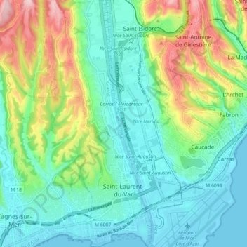
Saint-Laurent-du-Var topographic map
Interactive map
Click on the map to display elevation.
About this map
Name: Saint-Laurent-du-Var topographic map, elevation, terrain.
Average elevation: 249 ft
Minimum elevation: -7 ft
Maximum elevation: 869 ft
Other topographic maps
Click on a map to view its topography, its elevation and its terrain.
Col de Nice
France > Provence-Alpes-Côte d'Azur > Maritime Alps > L'Escarène
Average elevation: 1,463 ft
Cime de la Bonette
France > Provence-Alpes-Côte d'Azur > Maritime Alps > Saint-Dalmas-le-Selvage
Average elevation: 8,241 ft
Mont Agel
France > Provence-Alpes-Côte d'Azur > Maritime Alps > Peille
Mont Agel is a mountain in the Maritime Alps on the border between France and Monaco. The summit of this mount, at 1,148 metres (3,766 ft) above sea level, is on the French side, but the highest point of Monaco, lying on a pathway named Chemin des Révoires, is on its slopes, at an altitude of 161 metres (528…
Average elevation: 2,592 ft
Pont du Loup
France > Provence-Alpes-Côte d'Azur > Maritime Alps > Tourrettes-sur-Loup
Average elevation: 1,991 ft
Les Galants
France > Provence-Alpes-Côte d'Azur > Maritime Alps > Escragnolles
Average elevation: 3,799 ft
La Sagne
France > Provence-Alpes-Côte d'Azur > Maritime Alps > Briançonnet
Average elevation: 4,055 ft
Berghe Inférieur
France > Provence-Alpes-Côte d'Azur > Maritime Alps > Fontan
Average elevation: 3,159 ft
Forte Colle Alto
France > Provence-Alpes-Côte d'Azur > Maritime Alps > Tende
Average elevation: 5,538 ft
Roya
France > Provence-Alpes-Côte d'Azur > Maritime Alps > Saint-Étienne-de-Tinée > Roya
Average elevation: 6,093 ft