Geolocate

Tadrart topographic map

Click on the map to display elevation.

About this map
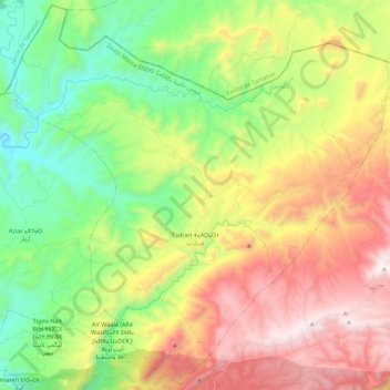
Name: Tadrart topographic map, elevation, terrain.

Location: Tadrart, caïdat d'Imouzzer, cercle d'Agadir-Atlantique, Préfecture d'Agadir Ida-Outanane, Souss-Massa, Maroc (30.69915 -9.56964 30.88451 -9.34867)

Average elevation: 2,871 ft

Minimum elevation: 971 ft

Maximum elevation: 5,551 ft

Other topographic maps

Click on a map to view its topography, its elevation and its terrain.

Tourarine

Maroc > Souss-Massa > cercle d'Agadir-Atlantique > Tamri

Average elevation: 1,854 ft

Imzi

Maroc > Souss-Massa > cercle d'Agadir-Atlantique > Imsouane

Average elevation: 653 ft

Tahanoute

Maroc > Souss-Massa > cercle d'Agadir-Atlantique > Aourir

Average elevation: 942 ft

Tamzayte

Maroc > Souss-Massa > cercle d'Agadir-Atlantique > Aourir

Average elevation: 1,749 ft

Tazmmour

Maroc > Souss-Massa > cercle d'Agadir-Atlantique > Taghazout

Average elevation: 1,532 ft

Tizgui

Maroc > Souss-Massa > cercle d'Agadir-Atlantique

Average elevation: 2,736 ft

Tagherat

Maroc > Souss-Massa > cercle d'Agadir-Atlantique

Average elevation: 2,274 ft

Gear up for your next adventure:

🪶Trail Camera - Capture wildlife on your hikes
🎒Trail Energy Bars - High‑calorie bars for hiking energy
🎒Waterproof Dry Bags - Keep your electronics and maps dry inside your pack
🎒Day Hiking Backpack - Lightweight backpack perfect for day trips and outdoor adventures
🔌Solar Panel Charger - Charge gear sustainably outdoors

As an Amazon Associate, this site earns from qualifying purchases at no extra cost to you.