
Make a donation
Gear up for your next adventure:
As an Amazon Associate, this site earns from qualifying purchases at no extra cost to you.
Brundorf topographic map
Click on the map to display elevation.
Make a donation
Gear up for your next adventure:
As an Amazon Associate, this site earns from qualifying purchases at no extra cost to you.
Brundorf
Schon in dieser Zeit schnitten sich zwei Straßen in Brundorf: Die spätere Poststraße von Osterholz nach Vegesack und die Landstraße von Bremen nach Brake, die heute nur noch als topographischer Einschnitt erkennbar ist. Die Nutzung der Wälder stand vom 17. bis zum 19. Jahrhundert den Gutsherren in Blumenthal und Schönebeck zu.
Make a donation
Gear up for your next adventure:
As an Amazon Associate, this site earns from qualifying purchases at no extra cost to you.
About this map
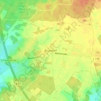
Name: Brundorf topographic map, elevation, terrain.
Average elevation: 115 ft
Minimum elevation: 43 ft
Maximum elevation: 167 ft
Make a donation
Gear up for your next adventure:
As an Amazon Associate, this site earns from qualifying purchases at no extra cost to you.
Other topographic maps
Click on a map to view its topography, its elevation and its terrain.
28790
Deutschland > Niedersachsen > Landkreis Osterholz > Schwanewede > Hinnebeck
Average elevation: 36 ft