Make a donation
Gear up for your next adventure:
As an Amazon Associate, this site earns from qualifying purchases at no extra cost to you.
Membruggen topographic map
Click on the map to display elevation.
Make a donation
Gear up for your next adventure:
As an Amazon Associate, this site earns from qualifying purchases at no extra cost to you.
Membruggen
Membruggen ligt op de grens van Vochtig- en Droog-Haspengouw op een hoogte van ongeveer 90 meter. Aan de Demerstraat bevindt zich één de bronnen van de Demer, hier Molenbeek genoemd. Langs deze beek vindt men het natuurreservaat Molenbeemd.
Make a donation
Gear up for your next adventure:
As an Amazon Associate, this site earns from qualifying purchases at no extra cost to you.
About this map
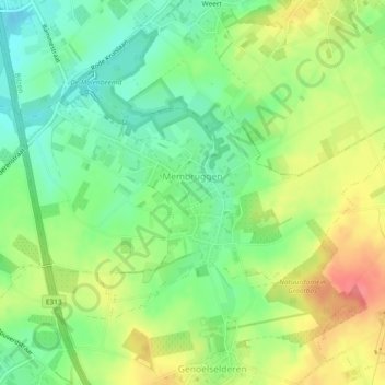
Name: Membruggen topographic map, elevation, terrain.
Location: Membruggen, Riemst, Tongeren, Limburg, België (50.80567 5.51354 50.82449 5.55968)
Average elevation: 302 ft
Minimum elevation: 207 ft
Maximum elevation: 427 ft
Make a donation
Gear up for your next adventure:
As an Amazon Associate, this site earns from qualifying purchases at no extra cost to you.
Other topographic maps
Click on a map to view its topography, its elevation and its terrain.
Make a donation
Gear up for your next adventure:
As an Amazon Associate, this site earns from qualifying purchases at no extra cost to you.
