
Make a donation
Gear up for your next adventure:
As an Amazon Associate, this site earns from qualifying purchases at no extra cost to you.
Astberg topographic map
Click on the map to display elevation.
Make a donation
Gear up for your next adventure:
As an Amazon Associate, this site earns from qualifying purchases at no extra cost to you.
About this map
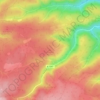
Name: Astberg topographic map, elevation, terrain.
Average elevation: 1,453 ft
Minimum elevation: 1,060 ft
Maximum elevation: 1,660 ft
Make a donation
Gear up for your next adventure:
As an Amazon Associate, this site earns from qualifying purchases at no extra cost to you.
Other topographic maps
Click on a map to view its topography, its elevation and its terrain.
Schierke
Deutschland > Sachsen-Anhalt > Landkreis Harz > Wernigerode
2011 wurde durch die Stadt Wernigerode ein umfangreiches Investitionsprogramm für Schierke aufgelegt. Bis 2015 flossen rund 40 Millionen Euro in die Ortsentwicklung, vor allem in Straßen, Brücken, Parkplätze, Hotels und Sportangebote. Das Konzept des Berliner Architekten Wolf-Rüdiger Eisentraut sieht vor,…
Average elevation: 2,320 ft
Make a donation
Gear up for your next adventure:
As an Amazon Associate, this site earns from qualifying purchases at no extra cost to you.
Bahnhofsvorplatz
Deutschland > Sachsen-Anhalt > Landkreis Harz > Wernigerode
Average elevation: 817 ft
Eckertalsperre
Deutschland > Sachsen-Anhalt > Landkreis Harz > Wernigerode > Schierke
Average elevation: 1,998 ft
Schierke
Deutschland > Sachsen-Anhalt > Landkreis Harz > Wernigerode
2011 wurde durch die Stadt Wernigerode ein umfangreiches Investitionsprogramm für Schierke aufgelegt. Bis 2015 flossen rund 40 Millionen Euro in die Ortsentwicklung, vor allem in Straßen, Brücken, Parkplätze, Hotels und Sportangebote. Das Konzept des Berliner Architekten Wolf-Rüdiger Eisentraut sieht vor,…
Average elevation: 2,316 ft