
East Troy topographic map
Click on the map to display elevation.
About this map
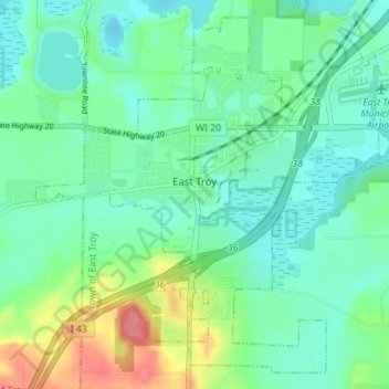
Name: East Troy topographic map, elevation, terrain.
Location: East Troy, Walworth County, Wisconsin, United States (42.75987 -88.43419 42.80684 -88.36425)
Average elevation: 866 ft
Minimum elevation: 797 ft
Maximum elevation: 1,050 ft
Walworth County trails, hiking, mountain biking, running and outdoor activities
Other topographic maps
Click on a map to view its topography, its elevation and its terrain.
Pell Lake
United States > Wisconsin > Walworth County > Village of Bloomfield
Average elevation: 863 ft