Geolocate

Gneis topographic map

Click on the map to display elevation.

About this map

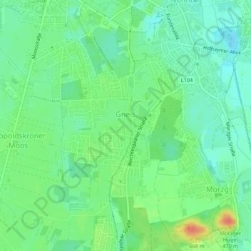
Name: Gneis topographic map, elevation, terrain.

Location: Gneis, Salzburg, 5020, Austria (47.77017 13.03047 47.78553 13.05084)

Average elevation: 1,414 ft

Minimum elevation: 1,358 ft

Maximum elevation: 1,522 ft

Gear up for your next adventure:

🪑Portable Camp Table - Compact table for campsite meals
🔥Fast-Boil Camping Stoves - Efficient cooking systems for quick trail meals
🛡️Insect Repellent - Protection against bugs during outdoor activities
🛰️Handheld GPS Units - Professional satellite navigators for precise backcountry mapping
🕶️GPS Smartphone Mount - Secure mount for phone navigation

As an Amazon Associate, this site earns from qualifying purchases at no extra cost to you.