Geolocate

Pore topographic map

Click on the map to display elevation.

About this map

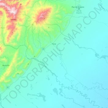
Name: Pore topographic map, elevation, terrain.

Location: Pore, Casanare, Colombia (5.52993 -72.11178 5.83975 -71.65932)

Average elevation: 1,152 ft

Minimum elevation: 571 ft

Maximum elevation: 4,911 ft

Gear up for your next adventure:

🌲Outdoor Survival Books - Best books on survival skills
🌧️Backpack Rain Cover - Keep gear dry in wet weather
🧺Microfiber Travel Towels - Compact and fast-drying towels for trail use
🪶Camping Sleeping Pad - Comfortable sleeping pad for backpacking
🔦Powerful Headlamps - Ultra-bright hands-free lighting for night navigation

As an Amazon Associate, this site earns from qualifying purchases at no extra cost to you.