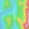
Diche I topographic map
Click on the map to display elevation.
About this map

Name: Diche I topographic map, elevation, terrain.
Location: Diche I, Widikum-Boffé, Momo, Northwest, Cameroon (5.83132 9.73521 5.87132 9.77521)
Average elevation: 2,228 ft
Minimum elevation: 1,585 ft
Maximum elevation: 3,747 ft
Other topographic maps
Click on a map to view its topography, its elevation and its terrain.