
Make a donation
Gear up for your next adventure:
As an Amazon Associate, this site earns from qualifying purchases at no extra cost to you.
Banga topographic map
Click on the map to display elevation.
Make a donation
Gear up for your next adventure:
As an Amazon Associate, this site earns from qualifying purchases at no extra cost to you.
About this map
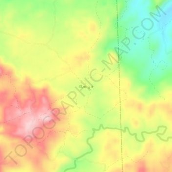
Name: Banga topographic map, elevation, terrain.
Location: Banga, Negros Occidental, Western Visayas, Philippines (9.76872 122.55719 9.80872 122.59719)
Average elevation: 1,020 ft
Minimum elevation: 633 ft
Maximum elevation: 1,375 ft
Make a donation
Gear up for your next adventure:
As an Amazon Associate, this site earns from qualifying purchases at no extra cost to you.
Other topographic maps
Click on a map to view its topography, its elevation and its terrain.
Candoni
Philippines > Negros Occidental
Candoni is located 130 kilometres (81 mi) south-south-west of the provincial capital, Bacolod. It is approximately four hour drive from Bacolod City aboard a public utility vehicle and about two hours and 45 minutes on a private car. From Bacolod City, buses are available at Bacolod South Terminal. From…
Average elevation: 1,010 ft
Make a donation
Gear up for your next adventure:
As an Amazon Associate, this site earns from qualifying purchases at no extra cost to you.
Make a donation
Gear up for your next adventure:
As an Amazon Associate, this site earns from qualifying purchases at no extra cost to you.