Geolocate

Malvern topographic map

Click on the map to display elevation.

About this map

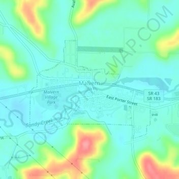
Name: Malvern topographic map, elevation, terrain.

Location: Malvern, Brown Township, Carroll County, Ohio, United States (40.68333 -81.19334 40.69815 -81.16913)

Average elevation: 1,047 ft

Minimum elevation: 974 ft

Maximum elevation: 1,257 ft

Carroll County trails, hiking, mountain biking, running and outdoor activities

Other topographic maps

Click on a map to view its topography, its elevation and its terrain.

Mechanicstown

United States > Ohio > Carroll County

Average elevation: 1,161 ft

Rockwood Park

United States > Ohio > Carroll County

Average elevation: 1,115 ft

Gear up for your next adventure:

🔊Portable Camp Speaker - Music and alerts at camp
🎒Trail Energy Bars - High‑calorie bars for hiking energy
🗺️NatGeo Topo Maps - High-quality waterproof printed topographic maps of US Parks
📻Weather Alert Radios - Stay informed of storm risks while off-the-grid
🌄Hiking Binoculars - Compact binoculars for scenic views and trail spotting

As an Amazon Associate, this site earns from qualifying purchases at no extra cost to you.