
Make a donation
Gear up for your next adventure:
As an Amazon Associate, this site earns from qualifying purchases at no extra cost to you.
Bati topographic map
Click on the map to display elevation.
Make a donation
Gear up for your next adventure:
As an Amazon Associate, this site earns from qualifying purchases at no extra cost to you.
Bati
Bati (Oromo: Baati; Amharic: ባቲ) is a town in north-central Ethiopia. Located in the Oromia Zone of the Amhara Region, east of Dessie this town has a latitude and longitude of 11°11′N 40°1′E / 11.183°N 40.017°E / 11.183; 40.017 with an elevation of 1502 metres above sea level. It is the largest town in Bati woreda.
Make a donation
Gear up for your next adventure:
As an Amazon Associate, this site earns from qualifying purchases at no extra cost to you.
About this map
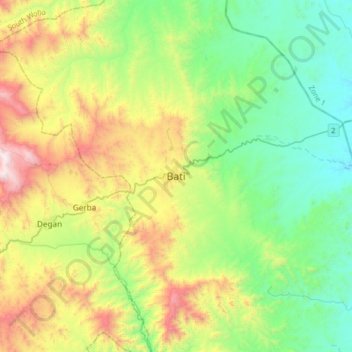
Name: Bati topographic map, elevation, terrain.
Location: Bati, Oromia, Amhara Region, Ethiopia (11.03163 39.85975 11.35163 40.17975)
Average elevation: 4,757 ft
Minimum elevation: 3,127 ft
Maximum elevation: 8,284 ft
Make a donation
Gear up for your next adventure:
As an Amazon Associate, this site earns from qualifying purchases at no extra cost to you.
Other topographic maps
Click on a map to view its topography, its elevation and its terrain.
Germama/kesem
The Germama is not a navigable stream, and flows with a great volume during the rainy season. It rises west of Kese Koremash, flowing east to the Awash, its course delineating a few kilometers of the northern boundary of the Awash National Park. The Kessem River passes an altitude drop from more than 2000 m on…
Average elevation: 4,285 ft
Make a donation
Gear up for your next adventure:
As an Amazon Associate, this site earns from qualifying purchases at no extra cost to you.