Geolocate

Waldeck topographic map

Click on the map to display elevation.

About this map

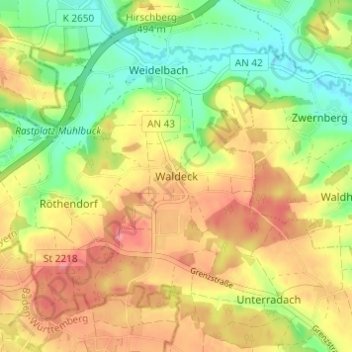
Name: Waldeck topographic map, elevation, terrain.

Location: Waldeck, Dinkelsbühl, Landkreis Ansbach, Bayern, Deutschland (49.08544 10.23019 49.12544 10.27019)

Average elevation: 1,578 ft

Minimum elevation: 1,447 ft

Maximum elevation: 1,703 ft

Other topographic maps

Click on a map to view its topography, its elevation and its terrain.

91550

Deutschland > Bayern > Landkreis Ansbach > Dinkelsbühl > Maulmacher

Average elevation: 1,558 ft

Gear up for your next adventure:

🔥Plasma Lighters - Windproof lighters that work in any weather condition
🎒Trail Energy Bars - High‑calorie bars for hiking energy
🦟Ultrasonic Repellers - Create a bug-free zone at your camp or rest stop
🔥Fast-Boil Camping Stoves - Efficient cooking systems for quick trail meals
🧭GPS Watch Accessories - Bands and chargers for GPS watches

As an Amazon Associate, this site earns from qualifying purchases at no extra cost to you.