
Make a donation
Gear up for your next adventure:
As an Amazon Associate, this site earns from qualifying purchases at no extra cost to you.
Naurod topographic map
Click on the map to display elevation.
Make a donation
Gear up for your next adventure:
As an Amazon Associate, this site earns from qualifying purchases at no extra cost to you.
About this map
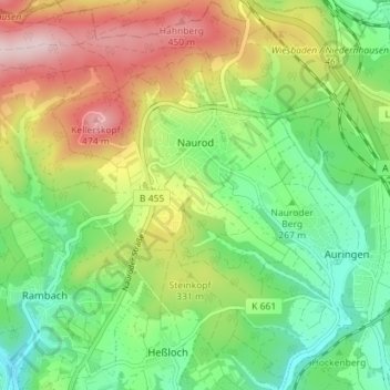
Name: Naurod topographic map, elevation, terrain.
Location: Naurod, Wiesbaden, Hessen, 65207, Deutschland (50.10628 8.27307 50.15181 8.32746)
Average elevation: 988 ft
Minimum elevation: 591 ft
Maximum elevation: 1,594 ft
Make a donation
Gear up for your next adventure:
As an Amazon Associate, this site earns from qualifying purchases at no extra cost to you.
Other topographic maps
Click on a map to view its topography, its elevation and its terrain.
Neroberg
Deutschland > Hessen > Wiesbaden
Im Wald hinter der Erlebnismulde gibt es seit dem Juni 2006 den Kletterwald Neroberg. Der Hochseilgarten mit etwa 80 Kletterelementen wurde in den Baumbestand integriert. Der Kletterwald Neroberg besteht aus mehreren Parcours in verschiedenen Höhen und mit unterschiedlichem Schwierigkeitsgrad.
Average elevation: 682 ft
Make a donation
Gear up for your next adventure:
As an Amazon Associate, this site earns from qualifying purchases at no extra cost to you.