
Make a donation
Gear up for your next adventure:
As an Amazon Associate, this site earns from qualifying purchases at no extra cost to you.
Tola Tola topographic map
Click on the map to display elevation.
Make a donation
Gear up for your next adventure:
As an Amazon Associate, this site earns from qualifying purchases at no extra cost to you.
About this map
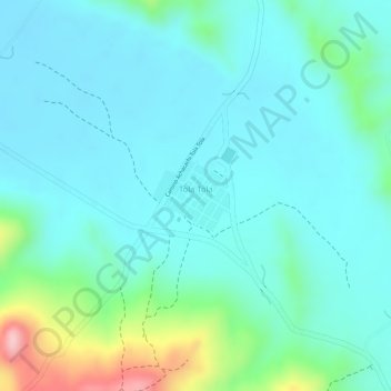
Name: Tola Tola topographic map, elevation, terrain.
Average elevation: 12,713 ft
Minimum elevation: 12,575 ft
Maximum elevation: 13,228 ft
Make a donation
Gear up for your next adventure:
As an Amazon Associate, this site earns from qualifying purchases at no extra cost to you.
Other topographic maps
Click on a map to view its topography, its elevation and its terrain.
Chijipina Grande
Bolivia > La Paz > Provincia Omasuyos > Municipio Achacachi
Average elevation: 12,533 ft
Jancoamaya Corpaputo
Bolivia > La Paz > Provincia Omasuyos > Municipio Achacachi
Average elevation: 13,428 ft
Chijipina Chico
Bolivia > La Paz > Provincia Omasuyos > Municipio Achacachi
Average elevation: 12,530 ft
Make a donation
Gear up for your next adventure:
As an Amazon Associate, this site earns from qualifying purchases at no extra cost to you.