
Thank you for supporting this site ❤️
Make a donation
Make a donation
Gear up for your next adventure:
As an Amazon Associate, this site earns from qualifying purchases at no extra cost to you.
Akdere topographic map
Click on the map to display elevation.
Thank you for supporting this site ❤️
Make a donation
Make a donation
Gear up for your next adventure:
As an Amazon Associate, this site earns from qualifying purchases at no extra cost to you.
About this map
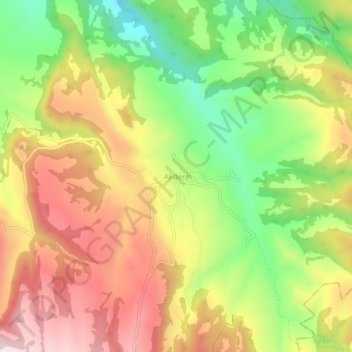
Name: Akdere topographic map, elevation, terrain.
Location: Akdere, Pamukkale, Denizli, Aegean Region, Turkey (38.02805 29.22327 38.06805 29.26327)
Average elevation: 2,989 ft
Minimum elevation: 2,300 ft
Maximum elevation: 3,661 ft
Thank you for supporting this site ❤️
Make a donation
Make a donation
Gear up for your next adventure:
As an Amazon Associate, this site earns from qualifying purchases at no extra cost to you.