
Thank you for supporting this site ❤️
Make a donation
Make a donation
Gear up for your next adventure:
As an Amazon Associate, this site earns from qualifying purchases at no extra cost to you.
Edelare topographic map
Click on the map to display elevation.
Thank you for supporting this site ❤️
Make a donation
Make a donation
Gear up for your next adventure:
As an Amazon Associate, this site earns from qualifying purchases at no extra cost to you.
Edelare
Edelare ligt nabij de Schelde. De hoogte varieert van 12,5 tot 55 meter. De Edelareberg bereikt een hoogte van 86 meter.
Thank you for supporting this site ❤️
Make a donation
Make a donation
Gear up for your next adventure:
As an Amazon Associate, this site earns from qualifying purchases at no extra cost to you.
About this map
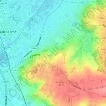
Name: Edelare topographic map, elevation, terrain.
Location: Edelare, Oudenaarde, Oost-Vlaanderen, België (50.82794 3.60844 50.84795 3.63777)
Average elevation: 128 ft
Minimum elevation: 20 ft
Maximum elevation: 295 ft
Thank you for supporting this site ❤️
Make a donation
Make a donation
Gear up for your next adventure:
As an Amazon Associate, this site earns from qualifying purchases at no extra cost to you.