Geolocate

Covadonga topographic map

Click on the map to display elevation.

About this map

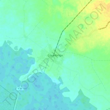
Name: Covadonga topographic map, elevation, terrain.

Location: Covadonga, Aguada de Pasajeros, Cienfuegos, Cuba (22.22946 -80.90822 22.30946 -80.82822)

Average elevation: 30 ft

Minimum elevation: 7 ft

Maximum elevation: 85 ft

Other topographic maps

Click on a map to view its topography, its elevation and its terrain.

Cienfuegos

Cuba > Cienfuegos

Average elevation: 72 ft

Cienfuegos

Cuba > Cienfuegos

Average elevation: 72 ft

Gear up for your next adventure:

📌Outdoor GPS Map App - Apps and devices for digital topographic navigation
🛠️Outdoor Gear Repair Kit - Essential tools to fix gear on the trail
📱Solar Portable Charger - Solar power bank for charging devices off‑grid
🩳Quick‑Dry Hiking Shorts - Comfortable and quick‑dry shorts for summer hiking
🔥Plasma Lighters - Windproof lighters that work in any weather condition

As an Amazon Associate, this site earns from qualifying purchases at no extra cost to you.