
Alegrete topographic map
Interactive map
Click on the map to display elevation.
About this map
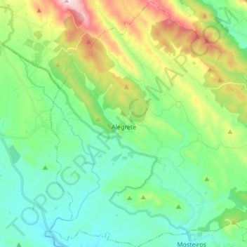
Name: Alegrete topographic map, elevation, terrain.
Location: Alegrete, Portalegre, Portugal (39.18912 -7.36279 39.29345 -7.23999)
Average elevation: 1,614 ft
Minimum elevation: 1,047 ft
Maximum elevation: 3,064 ft
Other topographic maps
Click on a map to view its topography, its elevation and its terrain.
Alagoinha de Baixo
Portugal > Portalegre > Portalegre
Alagoinha de Baixo, Reguengo e São Julião, Portalegre, 7300-469, Portugal
Average elevation: 2,218 ft
Carreiras
Portugal > Portalegre > Portalegre
Carreiras, Portalegre, 7300-355, Portugal
Average elevation: 1,883 ft
Vargens
Portugal > Portalegre > Portalegre
Vargens, Reguengo e São Julião, Portalegre, 7300-459, Portugal
Average elevation: 2,096 ft