
Carreiras topographic map
Interactive map
Click on the map to display elevation.
About this map
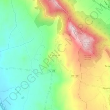
Name: Carreiras topographic map, elevation, terrain.
Location: Carreiras, Portalegre, 7300-355, Portugal (39.35200 -7.45223 39.39200 -7.41223)
Average elevation: 1,883 ft
Minimum elevation: 1,322 ft
Maximum elevation: 2,717 ft
Other topographic maps
Click on a map to view its topography, its elevation and its terrain.
Alagoinha de Baixo
Portugal > Portalegre > Portalegre
Alagoinha de Baixo, Reguengo e São Julião, Portalegre, 7300-469, Portugal
Average elevation: 2,218 ft
Vargens
Portugal > Portalegre > Portalegre
Vargens, Reguengo e São Julião, Portalegre, 7300-459, Portugal
Average elevation: 2,096 ft