Geolocate

Cijengkol topographic map

Click on the map to display elevation.

About this map

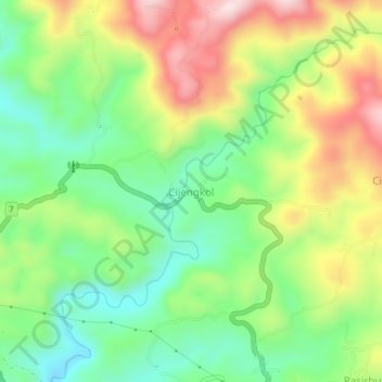
Name: Cijengkol topographic map, elevation, terrain.

Location: Cijengkol, Lebak, Banten, Java, Indonesia (-6.92928 106.33729 -6.88928 106.37729)

Average elevation: 1,106 ft

Minimum elevation: 551 ft

Maximum elevation: 1,909 ft

Other topographic maps

Click on a map to view its topography, its elevation and its terrain.

Gunung Halimun Salak National Park

Indonesia > Banten > Lebak

Average elevation: 1,650 ft

Gear up for your next adventure:

📷Action Cameras - Rugged cameras to document your journeys across rugged terrain
🍳Camping Cook Set - Complete cookware for outdoor meals
🎒Outdoor Daypacks - Lightweight backpacks designed for carrying maps and essential gear
🧦Merino Wool Socks - Moisture-wicking, blister-preventing socks for long treks
🪄Magnetic Compass - Accurate compass for navigation

As an Amazon Associate, this site earns from qualifying purchases at no extra cost to you.