
Thank you for supporting this site ❤️
Make a donation
Make a donation
Gear up for your next adventure:
As an Amazon Associate, this site earns from qualifying purchases at no extra cost to you.
Almunia topographic map
Click on the map to display elevation.
Thank you for supporting this site ❤️
Make a donation
Make a donation
Gear up for your next adventure:
As an Amazon Associate, this site earns from qualifying purchases at no extra cost to you.
About this map
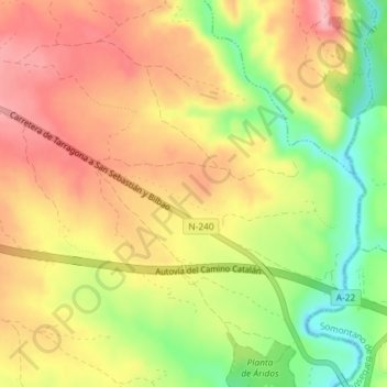
Name: Almunia topographic map, elevation, terrain.
Location: Almunia, Angüés, Hoya de Huesca, Huesca, Aragón, 22123, España (42.09129 -0.13245 42.11129 -0.11245)
Average elevation: 1,549 ft
Minimum elevation: 1,293 ft
Maximum elevation: 1,742 ft
Thank you for supporting this site ❤️
Make a donation
Make a donation
Gear up for your next adventure:
As an Amazon Associate, this site earns from qualifying purchases at no extra cost to you.