
New Hope Landing topographic map
Click on the map to display elevation.
About this map
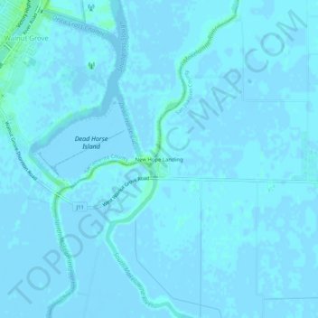
Name: New Hope Landing topographic map, elevation, terrain.
Average elevation: 3 ft
Minimum elevation: -10 ft
Maximum elevation: 30 ft
San Joaquin County trails, hiking, mountain biking, running and outdoor activities
Other topographic maps
Click on a map to view its topography, its elevation and its terrain.
Shumway Oak Grove Regional Park
United States > California > San Joaquin County > Stockton
Average elevation: 10 ft
Mountain House
United States > California > San Joaquin County
Mountain House lies on the foothills of the Diablo Range, and close to the Altamont Pass which is over 1,000 feet (300 m) in elevation. It is on the border of Alameda and Contra Costa counties. According to the United States Census Bureau, the CDP covers an area of 7.5 square miles (19.3 km2), nearly all of it…
Average elevation: 79 ft
Lathrop
United States > California > San Joaquin County
The San Joaquin River cuts through the middle of Lathrop, the Old River (California) on the west side, and has elevation of 20 feet (7 m).
Average elevation: 23 ft
Lodi
United States > California > San Joaquin County
Lodi is flat terrain at an elevation of approximately 50 feet (15 m) above mean sea level datum. Historically, land in the area has been used for grazing as well as for grain production.
Average elevation: 49 ft
Lathrop
United States > California > San Joaquin County
Lathrop is located at 37°49′1″N 121°17′19″W / 37.81694°N 121.28861°W / 37.81694; -121.28861 (37.816904, -121.288633). The San Joaquin River cuts through the middle of Lathrop, the Old River (California) on the west side, and has elevation of 20 feet (7 m).
Average elevation: 23 ft
Lathrop
United States > California > San Joaquin County
The San Joaquin River cuts through the middle of Lathrop, the Old River (California) on the west side, and has elevation of 20 feet (7 m).
Average elevation: 23 ft
Lodi
United States > California > San Joaquin County
Lodi is flat terrain at an elevation of approximately 50 feet (15 m) above mean sea level datum. Historically, land in the area has been used for grazing as well as for grain production.
Average elevation: 49 ft
Mountain House
United States > California > San Joaquin County
Mountain House lies on the foothills of the Diablo Range, and close to the Altamont Pass which is over 1,000 feet (300 m) in elevation. It is on the border of Alameda and Contra Costa counties. According to the United States Census Bureau, the CDP covers an area of 3.2 square miles (8.3 km2), all of it land.…
Average elevation: 79 ft
Lodi
United States > California > San Joaquin County
Lodi is flat terrain at an elevation of approximately 50 feet (15 m) above mean sea level datum. Historically, land in the area has been used for grazing as well as for grain production.
Average elevation: 10 ft