
Eton topographic map
Click on the map to display elevation.
About this map
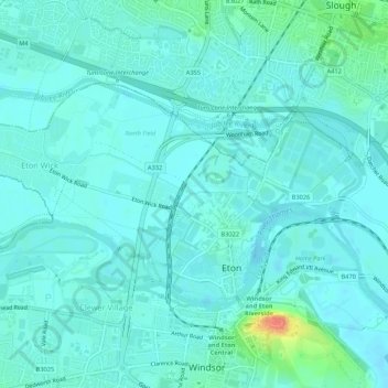
Name: Eton topographic map, elevation, terrain.
Average elevation: 75 ft
Minimum elevation: 49 ft
Maximum elevation: 210 ft
Other topographic maps
Click on a map to view its topography, its elevation and its terrain.
Maidenhead
United Kingdom > England > Royal Borough of Windsor and Maidenhead
Average elevation: 135 ft
Windsor Marina
United Kingdom > England > Royal Borough of Windsor and Maidenhead > Oakley Green
Average elevation: 85 ft
Silwood Park
United Kingdom > England > Royal Borough of Windsor and Maidenhead > Beggar's Bush
Average elevation: 200 ft
Braywoodside
United Kingdom > England > Royal Borough of Windsor and Maidenhead
Average elevation: 141 ft
Knowl Hill
United Kingdom > England > Royal Borough of Windsor and Maidenhead
Average elevation: 223 ft
Sunninghill
United Kingdom > England > Royal Borough of Windsor and Maidenhead
Average elevation: 220 ft
Cookham Rise
United Kingdom > England > Royal Borough of Windsor and Maidenhead
Average elevation: 144 ft
Magna Carta Island
United Kingdom > England > Royal Borough of Windsor and Maidenhead > Wraysbury
Average elevation: 105 ft
Cookham Dean
United Kingdom > England > Royal Borough of Windsor and Maidenhead
Average elevation: 164 ft
Bridge Gardens
United Kingdom > England > Royal Borough of Windsor and Maidenhead > Maidenhead
Average elevation: 98 ft
Upton Court Park
United Kingdom > England > Royal Borough of Windsor and Maidenhead > Slough
Average elevation: 75 ft
Formosa Island
United Kingdom > England > Royal Borough of Windsor and Maidenhead > Cookham
Average elevation: 157 ft
Burchett's Green
United Kingdom > England > Royal Borough of Windsor and Maidenhead > Hurley
Average elevation: 223 ft
Windsor Castle
United Kingdom > England > Royal Borough of Windsor and Maidenhead > Windsor > Clewer Village
Average elevation: 75 ft
Oakley Green
United Kingdom > England > Royal Borough of Windsor and Maidenhead
Average elevation: 121 ft
Windsor Castle
United Kingdom > England > Royal Borough of Windsor and Maidenhead > Windsor > Clewer Village
Average elevation: 75 ft
Windsor Castle
United Kingdom > England > Royal Borough of Windsor and Maidenhead > Windsor > Clewer Village
Average elevation: 75 ft
Sunninghill
United Kingdom > England > Royal Borough of Windsor and Maidenhead
Average elevation: 220 ft
Cookham Rise
United Kingdom > England > Royal Borough of Windsor and Maidenhead
Average elevation: 144 ft
Cookham Dean
United Kingdom > England > Royal Borough of Windsor and Maidenhead
Average elevation: 164 ft
Windsor Castle
United Kingdom > England > Royal Borough of Windsor and Maidenhead > Windsor > Clewer Village
Average elevation: 75 ft
Maidenhead
United Kingdom > England > Royal Borough of Windsor and Maidenhead
Average elevation: 135 ft
Maidenhead
United Kingdom > England > Royal Borough of Windsor and Maidenhead
Average elevation: 135 ft