Geolocate

Chenaran topographic map

Click on the map to display elevation.

About this map

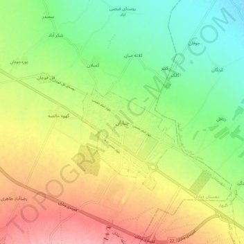
Name: Chenaran topographic map, elevation, terrain.

Location: Chenaran, شهر چناران, بخش مرکزی شهرستان چناران, Chenaran County, Razavi Khorasan, Iran (36.60840 59.07850 36.68840 59.15850)

Average elevation: 3,852 ft

Minimum elevation: 3,691 ft

Maximum elevation: 4,042 ft

Other topographic maps

Click on a map to view its topography, its elevation and its terrain.

Gear up for your next adventure:

Solar GPS Watches - Advanced multisport watches with built-in topographic maps
🧤Tactile Hiking Gloves - Keep hands warm while operating GPS and smartphone screens
👖Convertible Hiking Pants - Versatile zip-off pants for changing altitudes and temperatures
🧴Hand Sanitizer - Keep hands clean while hiking
🛰️Satellite Messengers - Emergency SOS and two-way messaging for off-grid adventures

As an Amazon Associate, this site earns from qualifying purchases at no extra cost to you.