
Tagus topographic map
Click on the map to display elevation.
About this map
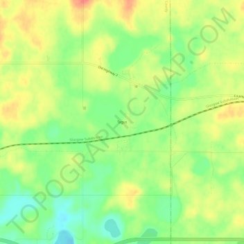
Name: Tagus topographic map, elevation, terrain.
Location: Tagus, Mountrail County, North Dakota, United States (48.32640 -101.95405 48.36640 -101.91405)
Average elevation: 2,201 ft
Minimum elevation: 2,110 ft
Maximum elevation: 2,293 ft
Mountrail County trails, hiking, mountain biking, running and outdoor activities
Other topographic maps
Click on a map to view its topography, its elevation and its terrain.
Palermo Wildlife Management Area
United States > North Dakota > Mountrail County > Stanley > Palermo
Average elevation: 2,149 ft