Geolocate

Hamilton topographic map

Click on the map to display elevation.

About this map

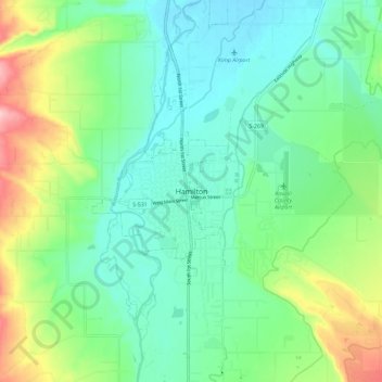
Name: Hamilton topographic map, elevation, terrain.

Location: Hamilton, Ravalli County, Montana, 59840, United States (46.20889 -114.19433 46.28889 -114.11433)

Average elevation: 3,658 ft

Minimum elevation: 3,494 ft

Maximum elevation: 4,068 ft

Ravalli County trails, hiking, mountain biking, running and outdoor activities

Gear up for your next adventure:

🔦LED Headlamp - Bright and durable LED headlamp for night navigation
🚁Photography Drones - Capture stunning aerial views of landforms and topography
🗺️NatGeo Topo Maps - High-quality waterproof printed topographic maps of US Parks
🔋Rechargeable Batteries - Power up your outdoor devices
🕶️GPS Smartphone Mount - Secure mount for phone navigation

As an Amazon Associate, this site earns from qualifying purchases at no extra cost to you.