Geolocate

Lawley topographic map

Click on the map to display elevation.

About this map

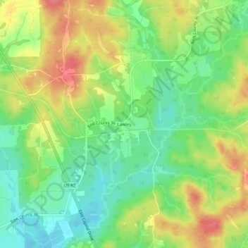
Name: Lawley topographic map, elevation, terrain.

Location: Lawley, Bibb County, Alabama, 35793, United States (32.83957 -86.97138 32.87957 -86.93138)

Average elevation: 456 ft

Minimum elevation: 351 ft

Maximum elevation: 584 ft

Bibb County trails, hiking, mountain biking, running and outdoor activities

Other topographic maps

Click on a map to view its topography, its elevation and its terrain.

Woodstock

United States > Alabama > Bibb County

Average elevation: 558 ft

West Blocton

United States > Alabama > Bibb County

Average elevation: 492 ft

Brent

United States > Alabama > Bibb County

Average elevation: 276 ft

Schultz Creek

United States > Alabama > Bibb County

Average elevation: 377 ft

Gear up for your next adventure:

🪑Portable Camp Table - Compact table for campsite meals
📶Vehicle Signal Boosters - Improve reception in rural areas while driving to trailheads
🔥Camping Stove - Portable stove for camping and backcountry cooking
📡Handheld GPS Device - Reliable handheld GPS for outdoor navigation
🌡️Portable Weather Meter - Track weather conditions on the trail

As an Amazon Associate, this site earns from qualifying purchases at no extra cost to you.