
North Decatur topographic map
Click on the map to display elevation.
About this map
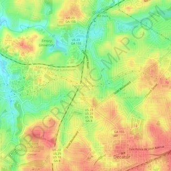
Name: North Decatur topographic map, elevation, terrain.
Location: North Decatur, DeKalb County, Georgia, 30322, United States (33.77039 -84.32626 33.81039 -84.28626)
Average elevation: 971 ft
Minimum elevation: 860 ft
Maximum elevation: 1,063 ft
DeKalb County trails, hiking, mountain biking, running and outdoor activities
Other topographic maps
Click on a map to view its topography, its elevation and its terrain.
Tucker
United States > Georgia > DeKalb County
Tucker, at 1,117 feet (340 m) feet above sea level, is the highest point of elevation on the railroad line between Atlanta and Richmond, Virginia.
Average elevation: 1,007 ft
Tucker
United States > Georgia > DeKalb County
Tucker, at 1,117 feet (340 m) above sea level, is the highest point of elevation on the railroad line between Atlanta and Richmond, Virginia.
Average elevation: 1,007 ft
Tucker
United States > Georgia > DeKalb County > Tucker
Tucker, at 1,117 feet (340 m) feet above sea level, is the highest point of elevation on the railroad line between Atlanta and Richmond, Virginia.
Average elevation: 1,040 ft
Tucker
United States > Georgia > DeKalb County
Tucker, at 1,117 feet (340 m) above sea level, is the highest point of elevation on the railroad line between Atlanta and Richmond, Virginia.
Average elevation: 1,007 ft