
Thank you for supporting this site ❤️
Make a donation
Make a donation
Gear up for your next adventure:
As an Amazon Associate, this site earns from qualifying purchases at no extra cost to you.
Djerba Island topographic map
Click on the map to display elevation.
Thank you for supporting this site ❤️
Make a donation
Make a donation
Gear up for your next adventure:
As an Amazon Associate, this site earns from qualifying purchases at no extra cost to you.
About this map
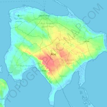
Name: Djerba Island topographic map, elevation, terrain.
Location: Djerba Island, ربانة, معتمدية جربة ميدون, Médenine, Tunisia (33.63144 10.72746 33.91573 11.06214)
Average elevation: 23 ft
Minimum elevation: -20 ft
Maximum elevation: 157 ft
Thank you for supporting this site ❤️
Make a donation
Make a donation
Gear up for your next adventure:
As an Amazon Associate, this site earns from qualifying purchases at no extra cost to you.