
Make a donation
Gear up for your next adventure:
As an Amazon Associate, this site earns from qualifying purchases at no extra cost to you.
Notzingen topographic map
Click on the map to display elevation.
Make a donation
Gear up for your next adventure:
As an Amazon Associate, this site earns from qualifying purchases at no extra cost to you.
About this map
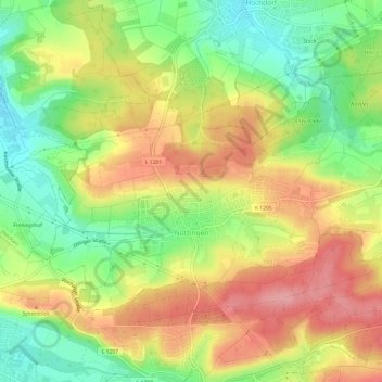
Name: Notzingen topographic map, elevation, terrain.
Average elevation: 1,099 ft
Minimum elevation: 912 ft
Maximum elevation: 1,283 ft
Make a donation
Gear up for your next adventure:
As an Amazon Associate, this site earns from qualifying purchases at no extra cost to you.
Other topographic maps
Click on a map to view its topography, its elevation and its terrain.
Egelsberg
Deutschland > Baden-Württemberg > Landkreis Esslingen > Weilheim an der Teck
Average elevation: 1,243 ft
Hofgut Tachenhausen
Deutschland > Baden-Württemberg > Landkreis Esslingen > Oberboihingen
Average elevation: 1,053 ft
Make a donation
Gear up for your next adventure:
As an Amazon Associate, this site earns from qualifying purchases at no extra cost to you.