
Make a donation
Gear up for your next adventure:
As an Amazon Associate, this site earns from qualifying purchases at no extra cost to you.
Ione topographic map
Click on the map to display elevation.
Make a donation
Gear up for your next adventure:
As an Amazon Associate, this site earns from qualifying purchases at no extra cost to you.
Ione
Ione is situated on the west bank of the Pend Oreille River as it flows north towards Canada. Big Muddy Creek, Little Muddy Creek and Cedar Creek, from south to north, join the river in Ione. State Route 31 passes through town. Ione Bridge, on the southern edge of town, is the only road crossing of the Pend Oreille between Metaline Falls to the north and Usk to the south. Being located in the Selkirk Mountains, the area immediately surrounding Ione is of high topographic relief. The town itself is on a relatively flat area along the river at an elevation of 2,090 feet above sea level, but the mountains rise dramatically both sides of the Pend Oreille. Cement Mountain, with its peak roughly a mile immediately north of town, rises to 3,003 feet. Molybdenite Mountain, across the river from Ione, rises even higher to 6,788 feet.
Make a donation
Gear up for your next adventure:
As an Amazon Associate, this site earns from qualifying purchases at no extra cost to you.
About this map
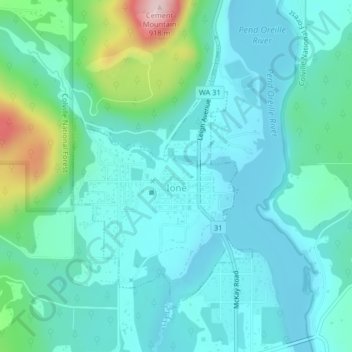
Name: Ione topographic map, elevation, terrain.
Average elevation: 2,198 ft
Minimum elevation: 2,014 ft
Maximum elevation: 2,976 ft
Pend Oreille County trails, hiking, mountain biking, running and outdoor activities
Make a donation
Gear up for your next adventure:
As an Amazon Associate, this site earns from qualifying purchases at no extra cost to you.
Other topographic maps
Click on a map to view its topography, its elevation and its terrain.
Make a donation
Gear up for your next adventure:
As an Amazon Associate, this site earns from qualifying purchases at no extra cost to you.