
Make a donation
Gear up for your next adventure:
As an Amazon Associate, this site earns from qualifying purchases at no extra cost to you.
Oosterzele topographic map
Click on the map to display elevation.
Make a donation
Gear up for your next adventure:
As an Amazon Associate, this site earns from qualifying purchases at no extra cost to you.
Oosterzele
Oosterzele ligt in zandig en zandlemig Vlaanderen. De hoogte varieert van 19-63 meter. Het hoogste punt bevindt zich bij de Betsberg. Het landschap is golvend. Enkele verlaten putten, waaruit vroeger Ledesteen werd gewonnen, zijn nog aanwezig.
Make a donation
Gear up for your next adventure:
As an Amazon Associate, this site earns from qualifying purchases at no extra cost to you.
About this map
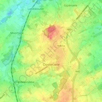
Name: Oosterzele topographic map, elevation, terrain.
Location: Oosterzele, Gent, Oost-Vlaanderen, België (50.93068 3.78189 50.97213 3.85114)
Average elevation: 118 ft
Minimum elevation: 30 ft
Maximum elevation: 223 ft
Make a donation
Gear up for your next adventure:
As an Amazon Associate, this site earns from qualifying purchases at no extra cost to you.
Other topographic maps
Click on a map to view its topography, its elevation and its terrain.
Gent
België > Oost-Vlaanderen > Gent > Gent
Een belangrijke waterloop voor Gent was de Lieve. De Lieve werd gegraven tussen 1251 en 1269 en vormde de eerste kunstmatige waterverbinding tussen Gent en de Noordzee. Over 45 km liep ze van Damme, waar ze in het Zwin uitmondde, naar Gent, waar ze in de Leie stroomde ter hoogte van het Gravensteen.
Average elevation: 39 ft
Make a donation
Gear up for your next adventure:
As an Amazon Associate, this site earns from qualifying purchases at no extra cost to you.