
Make a donation
Gear up for your next adventure:
As an Amazon Associate, this site earns from qualifying purchases at no extra cost to you.
Benton topographic map
Click on the map to display elevation.
Make a donation
Gear up for your next adventure:
As an Amazon Associate, this site earns from qualifying purchases at no extra cost to you.
About this map
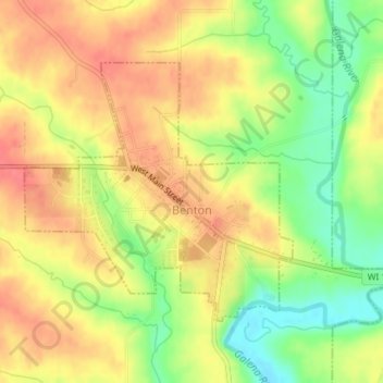
Name: Benton topographic map, elevation, terrain.
Location: Benton, Lafayette County, Wisconsin, United States (42.56154 -90.39697 42.57977 -90.37126)
Average elevation: 876 ft
Minimum elevation: 751 ft
Maximum elevation: 965 ft
Lafayette County trails, hiking, mountain biking, running and outdoor activities
Make a donation
Gear up for your next adventure:
As an Amazon Associate, this site earns from qualifying purchases at no extra cost to you.
Other topographic maps
Click on a map to view its topography, its elevation and its terrain.
Lead Mine
United States > Wisconsin > Lafayette County > Town of New Diggings
Average elevation: 866 ft
Ipswich
United States > Wisconsin > Lafayette County > Town of Elk Grove > Ipswich
Average elevation: 1,030 ft